ForeFlight adds new weather radar layer
iPad Pilot News
ForeFlight’s interactive map is the first place most pilots go when planning a flight to view a composite display of aviation charts, terrain, airspace, weather and much more. One of the most useful overlays here is the weather radar layer, which provides a big-picture view of your planned route in relation to current precipitation returns.
The latest app update includes a new and improved radar layer, in addition to a few other new features in the app. Here’s a quick summary of what’s new based on subscription type, with full details included below:
Basic – New “Beta” radar layer, map annotations eraser, logbook filtering, hide airspace activated by NOTAM
Pro Plus – Interactive flight profile line in the Profile view
Performance Plus with Runway Analysis – Missed approach climb requirements, added support for Citation C700 Longitude and Dassault Falcon 2000
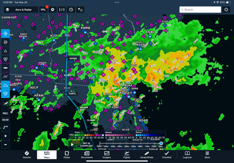
New “Beta” Radar Layer
ForeFlight transitioned to a new weather radar provider late last year, which affected how the precipitation returns were rendered in the app. As many pilots noticed after the update, the radar graphics looked pixelated, and there were often reliability issues with the refresh rate.
The ForeFlight team has been hard at work developing a new radar layer, and it’s now available in the latest version of the app as the Radar (beta) layer. The first thing you’ll notice compared to the original radar depiction is smoother, less pixelated imagery that updates much faster:

ForeFlight decided to keep the original radar layer around, for now, to allow pilots to compare it with the new layer during the transition. While the new layer is named “beta” to differentiate it from the original radar layer, the source data is the same as the original radar layer.
Logbook filtering
You’ll find a new filter button at the top of the Logbook screen, which lets you quickly filter your flights by date range, aircraft type, airport, instrument or night conditions, flight role and much more.

Map annotations eraser
When enabled, the map annotations tool allows you to mark up the main map using an interactive drawing tool. To allow for more control, ForeFlight added a dedicated eraser tool in the top menu, which allows you to erase specific annotations without clearing them all out at once.

Airspace activated by NOTAM
Certain types of special-use airspace, like many Military Operations Areas (MOA), are active based on a set schedule (e.g., M-F 13:30 – 16:30). Other MOAs are only activated by NOTAM, as shown in the details here for the Drifter MOA:

To help declutter the airspace view for certain flight planning scenarios, ForeFlight added a new setting in the Airspace section of the Aeronautical Map settings called “Activation by NOTAM.” When this setting is disabled, airspace that is only activated by NOTAM will be hidden. You can see here that the same Drifter MOA is no longer shown on the map when this setting is turned off:

If you do decide to disable the display of Airspace activated by NOTAM, we recommend always checking the separate NOTAM layer on the map to view the status of this type of special-use airspace before each flight:

Interactive flight profile line
Pro Plus subscribers can now interact with the profile view by tapping and dragging in this space to locate hazards and easily visualize the profile corridor along your route. Drag your finger left and right to move the line to view the height above terrain and hazards, as well as highlight hazards, obstacles, and airspace on the map.

The post ForeFlight adds new weather radar layer first appeared on iPad Pilot News.
The post ForeFlight adds new weather radar layer appeared first on iPad Pilot News.
Source: Ipad appsForeFlight adds new weather radar layer