
One of ForeFlight’s strengths compared to other aviation apps is its ability to take common flight planning data and present it in meaningful ways to help pilots make better-informed decisions. The latest update, version 12.1, continues this focus with three new features designed to help with route planning on the ground and reduce workload in the air when viewing datalink weather imagery.
Runway NOTAMs in Procedure Advisor
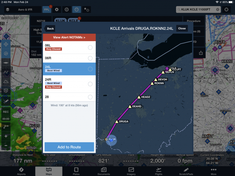
It’s safe to say if you open ForeFlight at least once before your flight and look at any screen related to your departure or destination airport that it’s impossible to miss an airport or runway closure. A larger red banner appears on the main Airports screen when there is a closure, along with a red banner on the pop-up airport window on the map. A red badge will also appear on the airport ID bubble in the route editor, indicating a closure of some type at that airport.
In the latest update, ForeFlight extended this warning to the Procedure Advisor screen. When viewing the list of runways for departures, approaches, arrivals, or traffic patterns in Procedure Advisor, ForeFlight adds a “See NOTAM” or “Rwy Closed” tag to any runway that is closed or partially closed by NOTAM.

Route Constraints
The Route Advisor feature in ForeFlight makes IFR flight planning a breeze by displaying recommended routes and recent ATC cleared routes that take the guesswork out of route selection. With the latest update, ForeFlight added the option to add additional constraints to further refine the route generated for your planned flight.
After pressing the Route Advisor button on the Route Editor screen, tap the button at the top right corner to access the Route Constraint settings window.

In addition to the previously-available altitude constraint fields, you’ll see three new options:
- Include waypoints – type in one or more navaids, waypoints or airports separated by commas or spaces to ensure the recommended routes include these in the route suggestions.
- Avoid waypoints – type in one or more navaids, waypoints or airports separated by commas or spaces to ensure the recommended routes do not include these in the route suggestions.
- Avoid FIR (Flight Information Regions) – select airspace sectors and regions you’d like to avoid overflying when planning a route. This is especially useful when flying internationally to help avoid dangerous or costly airspace.
Weather-layer auto altitude select
When flying with an ADS-B or XM receiver, several of the weather layers are altitude-based (Winds Aloft, Icing and Turbulence, and ADS-B Cloud Tops) and allow you to select an altitude using a slider on the right side of the screen. You’ll now see an Auto button appear at the top of the slider when viewing in-flight datalink weather, which will automatically select the closest altitude to your GPS-based altitude. This is a nice touch to make sure you’re always viewing the most relevant info without having to manually select an altitude throughout your flight.

The post ForeFlight 12.1 makes your flight planning smarter appeared first on iPad Pilot News.
Source: Ipad appsForeFlight 12.1 makes your flight planning smarter