Garmin Pilot has expanded tremendously over the last few years, adding features and options that make it an all-in-one pilot resource. In spite of all the sophisticated in-flight tools, like synthetic vision and datalink weather, one of the most useful features of any EFB app is still flight planning. Garmin Pilot offers a number of ways to find the right route.
The question comes up on almost every flight: you know you need to fly from your home base to another airport, but what’s the best route? Direct-to is unlikely if you’re IFR, and even if you’re VFR, that simple answer often isn’t the best one. Avoiding terrain, weather, airspace and even expensive avgas are all good reasons to modify your route. Here are 5 ways to do just that in Garmin Pilot.
Flight plan entry
This is the most familiar for many pilots, and if you know exactly the route you want to fly, it is very efficient. Tap the Home button, then Flight Plan. At the top left you can type your route in the Enter Waypoints box. The best way to do this is to use 3- or 4-letter codes, just like a flight plan (e.g., KOSH for an airport or HYK for a VOR). However, you can type in city names and the app will offer suggestions just above the keyboard.

Tap to add
If you don’t know the exact waypoints, use one of Garmin Pilot’s visual tools. First type in your departure and destination airports on the Flight Plan page. On the right side of the screen you’ll see a map with a preview of your route; tap on the “Tap Waypoints” button at the top right of the screen. Now you can tap on any airport, VOR, NDB or intersection and it will automatically be added to your route. This is good for quickly adding a convenient VOR or a fuel stop. You can even create user waypoints or add a lat/lon point from here.

Freehand
The other option on the right side of the Flight Plan page is Freehand. When this is tapped, you can literally draw your route right on the map and Garmin Pilot will fill in the waypoints. This is the lazy pilot’s way to do flight planning, but it works really well! We particularly like this option for routing around large bodies of water, TFRs or airspace – it’s great for long VFR flights.

After drawing the route, you’ll see a proposed flight plan both on the map and in your waypoint list on the left side. In our experience, the app will add enough waypoints to define your route, but not so many that the flight plan becomes unwieldy.

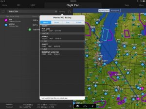
ATC routes
This is our preferred option for IFR pilots, especially when you’re flying to busy airports. Instead of guessing what routing you might get, let history be your guide. After entering your departure and destination airports, tap the “Routing” button just to the right of your waypoints. Garmin Pilot will display what routes other pilots have received from ATC.
Beyond a basic list, this is sorted multiple ways to help you find the right one. The first option, “Altitude,” is a great one since it allows you to ignore the 39,000 ft routes in your 172. We also like the “Popular” tab, which lists how often each route has been used, so you get a sense for which ones are preferred. Simply tap on one of these routes to make it the active one.

Stored
Finally, if you find yourself flying the same few trips all the time, you’ll quickly learn the routing to expect. Once you’ve entered that flight plan, tap Menu at the top right, then Store Flight Plan. This will be saved to your Garmin account, so you can access it from any device that uses the same account.

Any other routing tricks you’ve learned with Garmin Pilot? Add a comment below
Source: Ipad apps5 ways to plan a route in Garmin Pilot