Dispatch from 1V0, Navajo Lake State Park, New Mexico: The wind howls through Race 53’s twin tails. A high-pitched whine. Ghosts shrieking.
Her wings rock back and forth, straining against the tie-down straps. The sky above is an evil dark grey-green. Fast-moving ash-grey clouds scuttle across the horizon.
The rain comes in waves, never stopping. Sometimes it’s light, creating an alligator-skin pattern of beaded water on my windshield. Sometimes it’s car wash-heavy, blocking any view of the outside world as it pounds on the Plexiglas dome above my head.
It’s cold. I’m cold.
There’s nothing on top of this remote mesa but the asphalt strip, a tiny apron with long steel cables to serve as one-size-fits-all tie-down anchors, and a windsock. There’s no fuel, no phone, no bathrooms, no shelter. Nothing.
Even the access road is rutted mud.

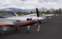
Race 53 found safe (but cold, wet, and lonely) harbor from the storm on a wind-swept mesa high above Navajo Lake in northern New Mexico. The 5,022-foot-long unattended strip sits at 6,478 feet above sea level. (Photo by William E. Dubois)
The rain is heavier again now. It’s drumming on my metal wings, a cacophony of noise. Suddenly, ice-cold water splashes my face, splattering my glasses. What the…?
I wipe the chilled water from my cheek and look up to see a drop of water forming where the two cabin doors meet at the top of the apex of the cockpit. The drop grows in size, detaches, and falls to my shoulder. Splat! As the drop hits the dark blue nylon of my winter flight jacket it explodes into spray.
The rain has found a way in.
I look back over my shoulder and see two tiny twin streams of water flowing in from the corners of my back windows. I reach back to touch the carpet on the luggage compartment floor. It’s soaked.
I quickly move what little gear I have with me into the front of the plane. The backup batteries for the Garmin. A snack bag. The case for my headset. My camera. The towbar and the plastic baskets that hold spare oil and cleaning supplies stay in the back to fend for themselves.
I shift the doors slightly to the right to get the drip above me off of my shoulder. The inside windows are now fully fogged over. I’m deprived off all sight beyond my cockpit walls, with only the sound of the wind and the rain for company.
By some miracle I have two bars on my iPhone. A check of the weather shows that it’s raining in my location. Ya think? Worse, the rain — which wasn’t predicted at all this morning — is set to last at least three hours. Maybe more. I’m not surprised. When it came roaring down out of nowhere at the northern rim of the San Juan basin, it looked as solid as a mountain.
I’m going to be here for a long time. Still, camped out in my cold, crowded, damp cockpit, I couldn’t be happier to be here if it were the Ritz-Carlton. Because not 20 minutes ago I was up in that angry sky, fighting turbulence so severe it felt like my shoulder belt would break, watching the gap between sky and ground shrink, with no airport behind me for 100 miles, a solid wall of rain blocking my way ahead, eyeing a remote dirt oilfield road that snaked along the bottom of the canyon and thinking it might be the best place to put down to escape the storm.
For the first time in my life I truly understand the old saying: Any safe harbor in a storm.
But if I had just left home literally 14 minutes earlier, it would have been a different story. And while I’m getting a free airplane wash on the heavy-duty cycle, my Garmin is showing clear skies at my original destination. Had I just flown there directly, instead of doing a complex workaround to avoid predicted bad weather, I’d be having a nice cup of coffee in the cushy warm terminal right now.
So, yeah, I’m happy to be safe. But I can’t help but kick myself in the ass for making the choices I made that got me to my safe harbor.
The forecasts
For days I had been seeing red. Lots of red at the Air Sports Net website (www.usairnet.com), my favorite go-to online for a great graphic depiction of ceiling and visibility. Not only do I love the way they present weather data, but I’ve found them to be highly accurate.
Which was why I couldn’t make sense of how day after day of low cloud ceilings and crappy visibility could be predicted for Pagosa Springs, Colorado — the launch point for the Pagosa Springs 160 Sport Air Race — with dew point temperature spreads of nearly 40°.

Seeing Red: For days the weather forecasts indicated less-than-perfect weather for the days leading up to the 9th running of the Pagosa Springs 160 Sport Air Race. This forecast led air racer William E. Dubois to alter his flight plan, with poor results. (Screen shot from Air Sports Net)
The next nearest cities in all directions were predicting clear skies and fair weather. So what was up with Pagosa? I checked other weather sources, of course, but the picture just got more muddled. What to do?
There’s a whole lot of landscape out in this part of the country with no gas stations for airplanes of limited range, so I decided the safest bet was not to attempt to fly from home to Pagosa — which can easily be done by going directly through the mountains — as I figured that if the weather went south on me, even with legal reserve plus sensible reserve, I could find myself parked on a remote highway with empty tanks.
So I played it “safe,” and chose to fly an end run around the Jemez Mountains south of Santa Fe and up the San Juan basin to Aztec, New Mexico. That would put me in a position to refuel and fly up the wide Piedra River Canyon towards Pagosa Springs, making it easy to turn tail and go back to Aztec if Pagosa really was socked in.
It was a longer flight, of course, but given the uncertain weather forecasts it seemed the safest bet.
It was a bad decision. But there was no way to know that at the time.
The only sign of trouble as I did a last minute check of weather before dawn was an Airmet for low-level turbulence for pretty much the entire southwestern United States. Huh. OK then.
I took off in brilliant sunshine with hardly a bump to be felt as I winged my way from Santa Rosa over Rowe Mesa, south of Santa Fe, across the heel of the Jemez Mountains, and up into the San Juan Basin.
Sixty miles from Aztec I saw the first cloud. A small cotton ball, 2,000 feet above. Far head, the horizon started darkening…
A different type of storm cloud
Back at Navajo Lake, where I took harbor to escape the storm, the rain finally stopped. Then started again. Then stopped. Hints of blue on the horizon to the northwest teased me, then vanished again.
The satellite view showed the storm was moving, and based on the speed, it looked like Pagosa would be clear later in afternoon. I’d wasted a lot of the day, but I could still make it. Clear skies hovered 30 miles away. Then the rain started again.
The weather pulsed. OK.
Not OK.
OK again.
Not OK.
It seemed it would never fully clear. Finally, during a break in the rain, I fired up and lifted off toward the blue horizon.
But as I slid under the edge of the storm, the turbulence hit once again, jarring the little two-seat antique racer left and right. Up and down. My headset thwacked against the window. I cinched my seat belt down more tightly, held the yoke with a death grip, and powered through it out into the sunshine. The sky settled down and I slid into a calm downwind for Aztec.
Where the new self-serve gas pumps weren’t working. There was no gas. There was no NOTAM about this.
And boy, was I pissed.
Thirteen miles in the wrong direction lay Farmington, New Mexico, a familiar place. The place where I took my private pilot check ride in 1983.
It was time for a homecoming.
A low ceiling and… Snow?
Standing on the ramp at Farmington, the sky in the direction of Pagosa looked menacing. I checked the live feed to the ramp cameras at Pagosa’s Stevens Field and was shocked to see heavy snow and clouds at the treetops.
I had missed my opportunity to get in before the storm hit. And then it hit me that my chain of bad decisions might have cost me the race. And the season.

Pre-dawn en route from Farmington, New Mexico to Pagosa Springs, Colorado, air race pilot William E. Dubois is worried about ground fog with a dew point temperature spread of zero. In the chilly morning air, the 85-horse power plane quickly climbed above the mountainous terrain. (Photo by William E. Dubois)
The forecasts that didn’t agree on today all agreed that tomorrow morning would be ushered in with low ceilings and fog. They would lift by race time, but that might not give me time to get there for the mandatory briefing. If team Ely was already there (they have an instrument capable plane; Race 53 is a VFR craft) and I didn’t make it, they would end the day 140 League points up on me. With only four races left in the season it would be all over for me.
On the satellite, the storm seemed to have stalled. There was nothing I could do. I turned to the lineman and asked about overnight hangar rental.
Race 53 re-fueled, oiled up, and stashed safely in a hangar, I made my way to the hotel that the FBO had arranged a discount with. I collapsed in a chair, took off my shoes, and rubbed some warmth back into my feet. Just for the hell of it, I decided to take one last look at the cameras at Steven’s field. I refreshed my screen and stared at it dumbfounded.
The sun was out at Pagosa.
It was a punch in the gut. Briefly, I considered going back to the airport, but the shadows were already getting long. The sun would be setting soon. The air would be cooling, the mountain peaks would be vomiting out downdrafts that would pour down their sides like the cold water that spilled into my cockpit a few hours ago. It was not the time of day to fly an 85-horse plane into the Rockies.
I hoped my decision to stay put, unlike all the others I had made that day, was the right one.
Misty canyons majesty
The pilot next to me is warming up his engine. I can see the glow of his instruments through his half-fogged windows. This wingtip lights cast a pool of red and a pool of green on the tarmac. There’s a hint of orange on the distant eastern horizon. This morning’s forecast could not be more different than when I went to bed. It calls for a clear, sunny day. My only worry is about the dew point temperature spread, now nearly non-existent, the recipe for ground fog for any area near water.
I can’t recall how far the Pagosa airport is from the local streams and lakes.
I crack my throttle, turn on my mags, prime the engine, flip on the master switch, and punch the starter. The prop obediently spins and the engine catches at once, giving off its uncharacteristically throaty growl that always causes other pilots to ask me, “What on earth have you got in that thing?”
As I lift off into the predawn light, I can see puffy white fog filling the Animas River canyon. The sun rises and fills the cockpit with soft yellow light. I turn off my wingtip lights. Below, every other valley is wrapped in cotton-like fog. Every other valley is clear.
Closing in on Pagosa, I sail by Chimney Rock, a distinctive pair of towering rock cliffs that served as an astronomical observatory to the pre-Pueblo peoples who made this area their home thousands of years ago.
The sun is shining brightly on the rocks. And on the runway of Stevens Field.

A welcome sight: Pagosa Springs’ Stevens Field bathed in sunlight the morning of the race. Ten hours before, the visibility was near zero with blowing snow. It’s the closest SARL race to Race 53’s home base, and should have taken just a hair over two hours to reach. Instead, it took air racer William E. Dubois two days to get from his home base to the race, thanks to challenging weather. Rising above the field is the 12,640-foot Pagosa Peak. In the far distance the tops of the Colorado Rockies rise to above 14,000 feet. (Photo by William E. Dubois)
I land and pull up to the pumps, counting the race planes on the ramp. As I open my canopy, a wave of frigid air pours in, and I see for the first time that the planes that made it in yesterday are covered with a thick layer of chunky ice from last night’s storm. The pilots are pouring windshield wiper fluid over the wings to try to melt the ice.
Maybe my decisions weren’t so bad after all. The commute from Farmington took only three quarters of an hour, my engine is nicely warmed up, and I’m not chipping ice off my airframe.

Few of the air racers arrived without weather tales to tell. Two of the race planes encountered hail inbound. The most heavily damaged was Steve Hammer’s Race 73, a Glasair 1 TD, which will take a little more than buffing to repair. (Photo by Lisa F. Bentson)
I’m the first to make it in today. Half the race fleet is spread out over the countryside, stranded at different airports en route. The race is pushed back to give everyone a chance to get in, including Team Ely, who, I’m told, are currently fog-bound in Santa Fe. I know that Santa Fe rarely gets fog, but when it does, it’s tenacious.

Race planes on the ramp at Pagosa Springs’ Stevens Field. Fall colors were beginning to paint the mountain slopes and the air had more than a bite to it. Racers who arrived before race day found thick layers of clear ice on their planes first thing in the morning. (Photo by Lisa F. Bentson)
In my heart I know it won’t happen, but I allow myself to hope they can’t make the race so that I can get ahead of them at least once this season.
And it didn’t happen. The weather gods, so cruel to all of us these last several days, relent. The fog lifts. Taxing off the ramp for the race start, I’m right behind the Elyminator.
Again.
Mountain racing
I’m not the last to launch on the course this time. One of the planes wouldn’t start in the cold mountain air. Another arrived late as we were starting to taxi, and the pilot had to go into the terminal to sign the liability waivers before the race director would let him join the course. But both quickly pass me once we’re underway.
Arriving right before the race, I’ve had no time to practice-fly the course. I’ve studied it on the flight charts of course, but it’s not the same thing. The course includes a lot of right-hand turns, which places me at a disadvantage, as I fly from the left of the plane.

The Pagosa Springs 160 Sport Air Race is flown along the edge of the mountains and out onto the high mesa lands of southwestern Colorado and northwestern New Mexico. This is a cockpit view of the right tail of Tail End Charlie during the race. (Photo by William E. Dubois)
I choose to stay low to better eyeball the turn points, but most are remote airstrips down in the mountain valleys, separated by high ridgelines. I climb. Dive. Turn. Climb again. Dive. I worry what the climbs are doing to my race speed, but I’m unopposed in my class and I’m having a blast.

On the final leg of the race, Chimney Rock is at the 11 O’clock position off the nose. Air racer William E. Dubois is preparing to dive for the finish line, which is over the next ridge. (Photo by William E. Dubois)
Although we’re racing between 8,000 and 10,000 feet, the cool air gives lift to my wings and is dense enough for my prop to take a healthy bite out of it. I easily soar over each ridge in turn.
At each turn point, tired-sounding judges radio me, “Are you the last plane?” Yep.
The Pagosa 160 didn’t offer a short course. By the time I get back the beer will be warm and the girls will be cold.
On the radio, I can hear each of the 12 planes ahead as they reach their turns, the fastest plane tearing up the course at three times my speed. But that fast, he can’t be enjoying the view as much as I. And the view from my race cockpit is breathtaking.
I scoot along the slopes of the craggy San Juan Mountains southwest of Wolf Creek Pass, then out onto the rugged mesa lands that snuggle up against the Rockies. To my left soaring grey, snow-capped mountains rise above me. Below my wings, a riot of fall colors paint the ground in yellows and oranges amongst the deep green pines. Roaring down a canyon, I’m at home with the ridgelines above my wings.
This is the country I learned to fly in.
As I approach the final turn, I laugh aloud. The turn point is on the apron at the Navajo Lake airstrip, the airport where I was stranded in the rain not 24 hours before. On it sits a solitary aircraft with the turn judge.

A GPS track of Race 53’s course around Turn 6, the very same apron the race plane rode out the storm on twenty-four hours earlier. The structures seen in the satellite view aren’t structures. They are oil wells. (Screen shot from CloudAhoy)
“Race 53, turn six,” I announce and sweep around the corner, left wing high in the clear dark blue sky, the black square of the apron off my right wing directly below me.
“Are you the last plane?” radios back the judge.

Low and fast: The finish line was at Capote Lake, a park owned and operated by the Southern Ute Tribe. The Tribe arranged for the park to be cleared and the finish line was placed more than 500 feet way from finish line judges and timers. During the briefing, pilots were told to fly as low as they liked, but not to dip their wings in the water. According to the GPS flight log onboard, Race 53 crossed the finish line at 83 feet AGL. (Photo by Lisa F. Bentson)
My League Points: 1,130. Despite the high altitude and a lot of climbing to avoid smacking into the terrain, I clocked a very respectable mountain race speed of 115.02 miles per hour.
My League Standing: I remain in second place behind — you guessed it — Team Ely, who now have 1,170 points. The point totals are higher for both of us, but the gap stays stable with them 40 points ahead, as we both made the race despite weather challenges, and both ran unopposed in our Classes.

Air Racer William E. Dubois with his First Place “trophy” for a win in his Class (of course his was the only plane in its class in this race). (Photo by Lisa F. Bentson)
I’m also in second place in the League overall, ahead of Experimental leader Ken Krebaum of Race 118, who pulled further ahead of long-time Experimental Gold Champ Jeff Barnes of Race 411, who was unable to make the Pagosa race, the second in a row that he’s missed.
I’m also 855 points ahead of the third place production racer. If I quit right now, I’d still have a second place season trophy sewed up. But that’s not going to happen. While the odds don’t look so great, I’m sticking to my guns.
Maybe the next fog bank won’t lift, and I want the gold.
Not that it looks likely. There are only four races left in the season. The next is in Greenwood, South Carolina, which was postponed thanks to Hurricane Matthew. Then we race in Jasper, Texas, where the Elys are paired against two slower planes while I take on a Cessna 150, which will be a tight race.
By mid October, Team Ely could have a very ugly lead over me. Unless a whole bunch of really slow planes come out to race against me.
Hint, hint, hint.
Source: http://generalaviationnews.comAir Racing from the Cockpit: A chain of bad decisions