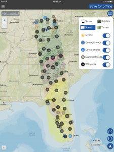
How many times have you been on a flight, either in general aviation airplanes or on the airlines, and looked down at a unique landmark on the ground and wondered what it was? A new app called Flyover Country can answer that exact question and help solve the mystery when flying across the U.S. on good weather days.
The free app was created by the University of Minnesota and was designed with outdoor enthusiasts in mind, providing access to extensive Wikipedia database and geologic maps from Macrostrat.org. It allows you to create a trip between 2 points in the US, and then saves all the relevant data and maps in an offline format so that you can view it in the air without an internet connection.
When used with a GPS (either the internal GPS iPad/iPhone or external accessory), it’ll track your location on the map and show you the nearby points of interests. Here’s a run down of how it all works.
Choose the approximate location of your departure and destination airports and tap “load path”
The app will display icons on the map showing various points of interests on 100 miles of either side of your flight plan
Press the Save for offline button at the top right to save the data for use in the air without an internet connection
Tap on the one of the icons for more information
Use the “What is that” feature from the main menu to learn more about various geographic features
You can download the app for free in the app store: Flyover Country
Source: Ipad appsGo aerial sight-seeing with Flyover Country


