While flashy features like synthetic vision, datalink weather and geo-referenced charts often dominate the conversation when it comes to mobile apps, there are countless other features under the hood that can play an equally important role in improving the safety and comfort of each flight.
The latest update to the Garmin Pilot app focuses on the latter, by adding a set of new smart features that highlight important information when planning a flight. This includes visual runway closures, contextual instrument approach NOTAMs, flight planning alerts, and TAF overlays on the map. Here’s a quick look at each.
Runway Closure NOTAMs
Depending on the source and presentation of your weather briefing, it can be difficult to isolate the few NOTAMs that really matter. There’s nothing more embarrassing than approaching an airport to land only to find that a runway, or the entire airport itself, is closed (and you missed the NOTAM during your pre-flight preparation).
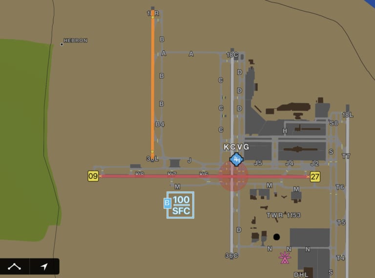
To help with this, Garmin Pilot now visually presents NOTAMs throughout the app to make sure this key information is not overlooked. First, closed runways are color-coded on the dynamic map or SafeTaxi diagram based upon the following classifications:
- Red runway with yellow X at each end – runway is closed.
- Orange runway with yellow clock – runway is closed; however, there are conditions that require further investigation, such as the time and/or date of its closure.
- Yellow runway – upcoming runway closure

When viewing the dedicated airports page, closed runways are noted with a red banner across the top of the screen, and a red “RWY CLSD” badge is placed next to the specific runway label.

Instrument Approach NOTAMs
When viewing an instrument approach chart or airport diagram, you’ll see a NOTAMs button at the bottom right of the screen. Tap on this to display applicable to NOTAMs to that particular procedure or chart.

Flight Planning Alerts
After entering the departe and destination airport in your flight plan, keep an eye on the Warnings button in the lower right corner of the screen. There will be an alert symbol displayed when one of the planned airports has a NOTAM for a closed runway — tap on it for details.

TAF and MOS Weather Overlays
In addition to displaying color-coded METAR symbols, Garmin Pilot now also displays the same VFR/MVFR/IFR color symbology for the forecast layer. These will display when selecting the TAF or MOS option from the Map Overlays menu and initially shows the forecast for the current time period. You can then use the slider at the bottom right of the screen to change the forecast period to observe forecast condition trends over a larger area.

The post Garmin Pilot adds visual NOTAMs in latest update appeared first on iPad Pilot News.
Source: Ipad appsGarmin Pilot adds visual NOTAMs in latest update