Since the early days of handheld and panel-mount GPS development, Garmin has been the leader in aviation when it comes to displaying intuitive and easy to read moving maps on their devices. Garmin’s proprietary data-driven moving maps are easily configurable to show the ground-based and aeronautical data needed for different types of flying, whether you’re a student pilot flying a VFR cross-country or a professional pilot relying on IFR navigation data.
Garmin’s interactive maps are even more powerful on the iPad in their Pilot app, thanks to the touch interface. The level of detail smoothly scales up and down as you pinch to zoom in and out, and any depicted item can be tapped for additional details. The latest update increases the utility of the moving map, by providing graphical airspace and obstacle NOTAMs. The update also adds new shortcuts on the Flight Profile view, improving the usability of this signature feature.
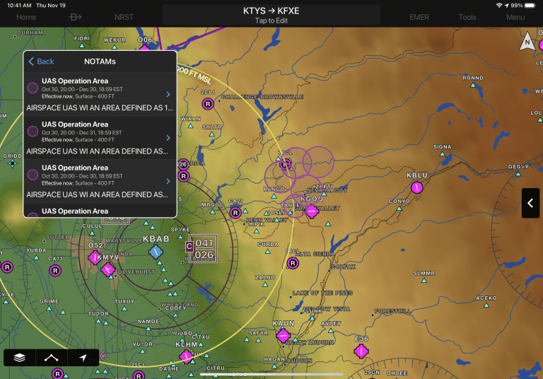
Graphical Airspace NOTAMs
The year is 2020, we’re in the midst of the FAA’s NextGen transition plan, and we’re still dealing with the same old text NOTAM distribution system from the FAA. Fortunately, app developers like Garmin have made great strides in taking this data and presenting it in more meaningful ways, to make sure pilots don’t miss the important NOTAMs in what can seem like an endless list during the preflight briefing.
The latest update from Garmin takes text Airspace NOTAMs and depicts them graphically on the moving map. You’ll find this very useful to quickly identify active Restricted airspace or MOAs, thanks to the bright colors used on the map. This feature will also depict parachute jumping areas, unmanned balloon launches, drone flights, aerobatic boxes, changes to instrument approach procedures and more.
To view airspace NOTAMs on the map, first enable the NOTAMs option from the map layer controls:

NOTAMs that are scheduled to become active in the next 24 hours are displayed in yellow to help alert pilots in advance and aid with flight planning, with a brighter contrast for areas showing upcoming restricted airspace. Active airspace NOTAMs are color-coded depending on the following classifications:
- Red: Restricted and Danger NOTAMs, such as Prohibited Areas
- Orange: Alert and Warning NOTAMs, including Military Operation Areas (MOA)
- Gray: Flight Data Center (FDC) NOTAMS such as Instrument Approach Procedure changes
- Purple: Other NOTAMs such as Parachute Jumping areas
You can view NOTAMs in both decoded and raw text by selecting the NOTAM segment in the radial menu.

Additionally, NOTAMs may also be viewed by selecting the NOTAMs widget in spilt-screen mode.

Graphical Obstacle NOTAMs
Obstacle NOTAMs can also be displayed on the map. These will be displayed when the same NOTAM layer or Obstacle layer is enabled. NOTAM’d obstacles will be displayed in pink to help differentiate them from regular obstacles, which are depicted in white. Tap one of the pink obstacles to view raw and decoded details.

You also have the ability to view an Obstacle NOTAM list from the airport page and by tapping the map icon for a selected NOTAM, jump to that NOTAM right on the map.

Flight Profile View Shortcut Buttons
You’ll find a new quick access bar in the Flight Profile View which allows you to quickly toggle flight layers such as weather, PIREPs, and traffic from compatible Garmin ADS-B traffic sources with a single tap. The flight profile view also allows for pinch to zoom gestures to zoom in tighter on certain segments of the flight.

The post Garmin Pilot improves display of NOTAMs in latest update appeared first on iPad Pilot News.
Source: Ipad appsGarmin Pilot improves display of NOTAMs in latest update