
Ten years to the day after Apple announced the iPad, ForeFlight released version 12.0 with some gee whiz features as usual, but some thoughtful improvements may be the more noticeable changes. Here’s a look at the new features.
Cleaner PIREP formatting
One of the under-appreciated features in ForeFlight (or any electronic flight bag app) is its ability to translate large quantities of coded text into easily digested data. METARs and TAFs were once short chunks of code but are now simple and readable weather reports. You don’t even have to convert from Zulu time.
Pilot Reports (PIREPs) have been an exception. While these real time updates from fellow pilots are invaluable for avoiding ice, finding a smooth ride, or figuring out how thick the clouds are, the formatting is hardly uniform. In this update, ForeFlight is trying to improve that situation with automatically translated PIREPs. Just tap on a PIREP symbol on the Maps page and you’ll see both the raw text and a decoded report. This makes it easier to scan for aircraft type, altitude, and time.

This isn’t perfect—the wide variety of reports and the particular abbreviations unique to each controller or flight service specialist makes this a tricky thing to translate—but it’s a major improvement and makes it much faster to scan a variety of PIREPs. Just as you should with a METAR, be sure to review the raw text to make sure you haven’t missed any important details.
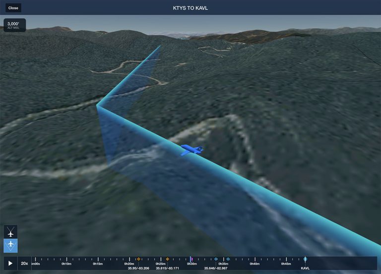
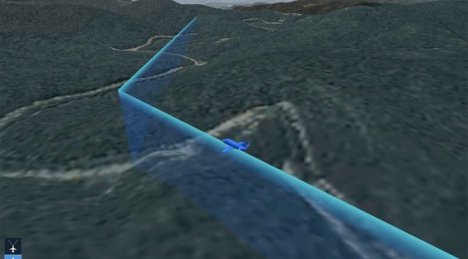
A new 3D view
The 3D view, available with Performance plans, definitely qualifies as a gee whiz feature but it has real value beyond impressing your passengers. Whether you’re debriefing a training flight or previewing an upcoming trip to an unfamiliar airport, this tool gives you a real world feel for the terrain around an airport.
The latest addition is a new camera angle, a so-called “exocentric view” that shows the airplane and route from the perspective of a chase plane. You can access this by tapping the 3D button in the FPL box (from the Maps page) or by tapping the 3D button on a track log (from the More page). The two buttons at the bottom left select the in-cockpit view or the chase plane view, and both now include a blue track line complete with altitude-appropriate height.

From the in-cockpit view, the app will simulate pitch and bank (if you recorded a flight with AHRS data, for example using a Stratus). From the chase plane view, you can pan and tilt to view all the surrounding terrain—a very helpful feature for making a complete evaluation of the area.
Garmin G1000 track logs
As track logs become a more important feature in ForeFlight, it’s important to be able to import them from as many devices as possible. The gold standard for track logging is a Garmin G1000 glass cockpit, and the app now supports importing these files.
The old fashioned way is to remove the SD card from your G1000, transfer the CSV file to a laptop, then email it to your iPad. This works, but starting with iOS 13, there’s an easier way. Your iPad can connect to an external SD card reader, which allows you to go directly to the Track Logs page from the More tab in ForeFlight. Tap the import button at the top right corner, choose Import from G1000 and find the correct track log. Once it’s imported (you’ll have the option to add a tail number if it’s a new airplane), this track log is treated like any other, whether it was recorded with the on-board GPS, a Stratus, or a G1000.
ForeFlight has a helpful video showing this in action:
Distance Rings get easier
Here’s another small change that makes a big difference. ForeFlight offers the option to display concentric range rings around your airplane, with either miles or minutes. It’s a nice aid to situational awareness, but it’s helpful to change between the options depending on the phase of flight. For example, we like to use minutes while in cruise flight (to help with fuel planning) but use miles around the airport (to help with identifying traffic).
Now it’s simple to switch back and forth. Just tap on any of the labels (e.g., 6nm) and a menu will pop up with the various options. You can turn Distance Rings on and off from the gear menu on the Maps page.

New Navlog template
Finally, ForeFlight has added a new option for the Navlog, which is accessed in the Flights tab. Select a flight from the left side list, then top on Navlog at the top to see a one page list of all essential information, from winds aloft to fuel remaining. You’ll notice a gear symbol at the top right corner now; tapping this brings up the option to use the Standard or International navlog template.

Both options show the same basic information, but the International style has more open space, which is particularly helpful if you like to print this out and mark it up. Here’s the Standard format at the top and the International at the bottom:

The post ForeFlight 12 adds new 3D tools, G1000 data import, and more appeared first on iPad Pilot News.
Source: Ipad appsForeFlight 12 adds new 3D tools, G1000 data import, and more