
The latest ForeFlight update includes a series of small, yet powerful features, that continue to expand the app’s capabilities. What’s interesting about this latest release is that you probably wouldn’t notice any of the new features if you updated and went about using the app in your normal routine. It highlights the importance of keeping up with each update as they become available in the app store and reviewing what’s new to get the most out of the app as it evolves. Here’s what to look for.
US VFR Flyway Charts on Maps
Think back to the pre-iPad days, when you kept a Sectional, Terminal Area Chart (TAC) and A/FD within easy reach in your flight bag. The TAC was especially useful when flying in and around Class B airspace, to see a greater level of detail to help in navigating the complex airspace. You may also recall the secondary resource printed on the back of the TAC, called a VFR Flyway chart, that depicts optimum VFR routing and visual landmarks when transitioning the airspace. It includes route arrows and altitudes to keep you under the Class B airspace and clear of the major Class B airport.

This resource has been in ForeFlight for years in the Documents section of the app, but it’s now available as a geo-referenced layer on the Maps screen. To view it, select the “U.S. VFR (flyway)” layer from the list of options, and zoom into an area that has a Class B airport (or the Florida Keys).

Improved map layers
ForeFlight’s moving map, with a sectional base layer and radar overlay, is fairly easy to view and manipulate. Things can get a little more complicated though when you combine aeronautical map features, multiple weather overlays and dynamic airspace. This often forces you to zoom in tight on the map to tap a specific layer and display more information about it.
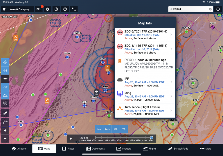
The latest update improves this a bit, allowing you to view information about multiple layer types simulataneously on the moving map. For example, in the following scenario, there is a turbulence AIRMET (colored light orange) in effect for the entire zoom level. After tapping the yellow TFR in the middle of the screen, an improved “Map Info” box appears, showing both the TFR and AIRMET. You can then tap on either one for more information. Previously tapping this area would have shown you info on the TFR, or info on the AIRMET, but not both at the same time.

In the next scenario, we tapped on a PIREP that was reported in an area with a TFR and 3 different types of AIRMETs. The Map Info shows preview data for each, greatly simplifying the interaction when attempting to get more info about layers on the map.

FBO info on aeronautical maps
The next to thing check out is the airport diagram depicted when zoomed in tight on the aeronautical map screen. ForeFlight now displays the FBO name and location with a blue dot here – tap it to view FBO information and fuel pricing.

Aircraft Sharing
This next feature is great for groups of pilots flying the same airplane, whether in a flight school, flying club or flight department. After one pilot sets up all the details for an aircraft profile, a new sharing function at the top right of the screen allows you to share it with other ForeFlight users using the standard methods (iMessage, Mail, etc.).
The recipient can then tap the link on their iPad or iPhone to accept the share. Shared aircraft are read-only, so recipients can’t change any of the aircraft’s details, but any changes made by the original owner are automatically synced to any recipients. This can be a big time saver, requiring only one pilot to set up the detailed aircraft equipment data required for ICAO flight plan filing.
What else is new
- Automatic night time logging – ForeFlight will now use your location and sunset/sunrise data to automatically log night time in the logbook
- New Document Types – adds support for comma-separated value files (CSV), and Apple Pages, Keynote, and Number files into ForeFlight’s Documents view.
- Expanded European Coverage – All European subscribers can now download AIPs for Albania, Bosnia and Herzegovina, Bulgaria, Cyprus, Moldova, North Macedonia, Romania, Serbia and Montenegro, and Turkey.
- European Graphical NOTAMs – Access graphical depictions of European enroute NOTAMs directly on ForeFlight’s map for improved flight planning and inflight situational awareness. Graphical NOTAMs are supported for all of Europe.
- FLARM NMEA support – Third-party devices that deliver FLARM traffic information in Europe via the NMEA protocol can now display that traffic within ForeFlight. ForeFlight also supports FLARM traffic from third-party devices using our extended GDL90 protocol, as well as via uAVionix’s SkyECho 2 ADS-B and FLARM transceiver.
The post ForeFlight expands map functionality in latest update appeared first on iPad Pilot News.
Source: Ipad appsForeFlight expands map functionality in latest update