
ForeFlight version 11 is now available, and it includes a number of interesting additions as usual. For Performance Plus and Business Performance subscribers the new 3D airport preview tool is the most interesting. Here’s how to use it.
Using Airport 3D View
ForeFlight has integrated a feature that we have long used in the Google Earth app – the ability to do a simulated fly-by of an airport to get a feel for the surrounding terrain. It’s a great way to plan your visual approach or evaluate whether you can safely land, and at the very least can build confidence. But while this feature will certainly improve preflight planning, it’s also a lot of fun. If you’ve ever dreamed of flying into Aspen or Innsbruck, now you can do it from your couch.
First, view an airport, either on the Airports page or by tapping on an airport on the Maps page. From either location, you’ll see a button for 3D View. Tap on this to launch the pop-up view.

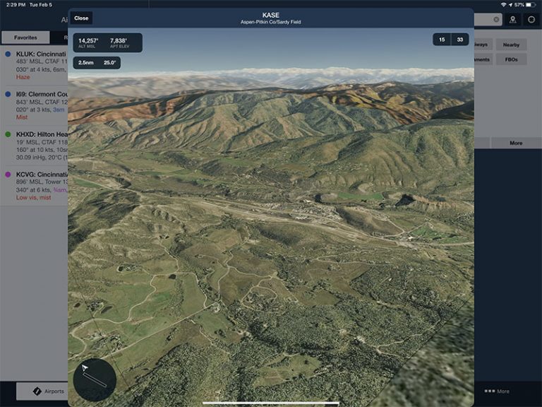
You’ll notice the app load in the aerial photo, but it’s more than just that. ForeFlight lays the photo on top of its high resolution terrain map for a 3D view of the terrain (notably, this feature works worldwide). By default you’ll be zoomed out above the airport, giving you a big picture view of the area. You can pinch to zoom in, just like you would on a 2D map. To pan around, tap and move the joystick control at the bottom left of the screen. Visualize yourself moving the camera angle when you do this and you’ll get the hang of it quickly. ForeFlight will stay centered on the airport itself, so you can zoom and tilt the camera but you cannot change the focal point.
As you move around, notice the data at the top left of the screen. This shows you the airport elevation right next to the camera’s altitude. So if you’re planning to arrive via a STAR and you expect to be at 5,000 feet, simply pull up until you’re at 5,000 feet to get a realistic preview. You’ll also see the distance from the airport in nautical miles and the angle you’re viewing currently (25 degrees in the example below).

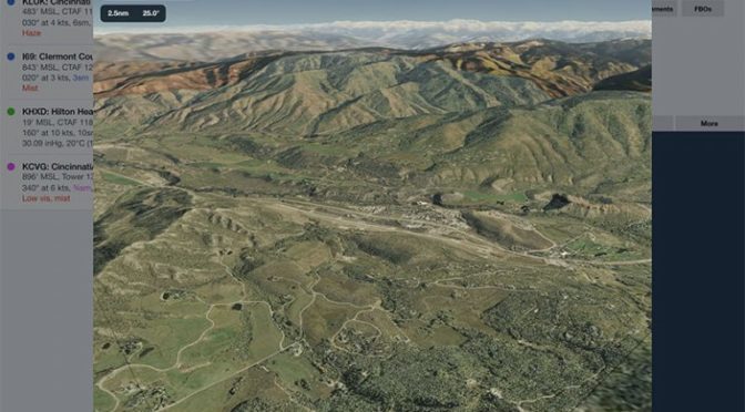
While that’s helpful for a general overview (where is the high terrain, what are some forced landing options, where is the FBO), you can also tap the runway numbers at the top right for a final approach preview. When you tap one of the runways, ForeFlight will move you out to 1nm and on the published glideslope (often 3 degrees), or 6 degrees if there is no published glidelsope. This is what the runway should look like as you prepare to land.
In this configuration, you can zoom out to see the approach on a 3 or 5 or 7 mile final at the same glideslope. Simply pinch to zoom out – the app stays centered on the runway end. Tap the runway button again to return to default position.
![]()
There’s one other detail to notice on this final approach view. A small windsock icon on the panning control shows the current wind direction, so you can choose the best runway for takeoff or landing.

Airport 3D View requires an internet connection to download the aerial imagery, but once downloaded the app will save it. So if you preview an airport before takeoff, you’ll be able to see it in flight. Airport 3D View is also included in the Pack feature.
More features
As usual, the latest ForeFlight release includes a number of enhancements, so Airport 3D View is just one. In-flight breadcrumbs have been added to the Track Log function, a tool we’ve been using since the days of black and white Garmin GPSs. You can view your track on the Maps page as it’s being recorded – simply turn on breadcrumbs from the map options menu (gear symbol at the top of the page). This is helpful for grading maneuvers (how clean was that turn around a point?), reviewing instrument approaches (were you really centered on the localizer?) or for unique missions like surveying or search and rescue.
You can tap on a breadcrumb line for details about the point, like average speed and time. Note that breadcrumbs are stored for about half an hour after a flight, so you can review them after a flight, but not forever. To permanently save breadcrumbs, tap on the line and tap Save as Track Log, which will send it to the Track Logs page. You can also delete breadcrumbs by tapping Delete. The Breadcrumbs feature is available for all subscription levels.

Graphical AIRMETs are also available now via ADS-B, so if you’re flying with a Stratus, Sentry, or GDL 50/52 you’ll have access to the FAA’s new format for weather advisories. You can filter AIRMETs by type (icing, tubulence, IFR conditions) and use the time slider to see the forecast conditions.
The popular Logbook feature now includes search. You can search for comments or equipment type, helpful if you’re trying to find a specific flight among hundreds of entries. Tap on All under Entries and you’ll see a Filter box at the top. You can also see all logbook entries that involved a particular person. Go to More -> Logbook -> People.
ForeFlight also supports KMZ files, an enhancement to the Content Packs feature. This is basically a more advanced version of a KML file, which allows fleet operators to add custom icons or map layers in a single file.
Finally, you can now search the ForeFlight settings, sort of like the feature that Apple added to iOS settings a few years ago. As the options have increased in the app, some pilots have struggled to find specific settings. Now you can type a phrase into the Filter box at the top and the app will show relevant settings in real time.
Subscription special
Airport 3D View, like many recent features, does require a Performance Plus or Business Performance Plan with ForeFlight. This is a $100/year premium over the Pro Plus plan (the most popular one in our experience), so it may not be for everyone. If you fly higher performance airplanes, or even if you just fly a lot of cross countries, we think it’s still an excellent value. Notable features include dummy-proof performance models, pre-departure clearances at busy airports, the helpful online Trip Assistant, and JetFuelX integration.
ForeFlight is also running a special – through February 18 you can get a 15-month subscription for the price of 12 months when you buy or upgrade to the Performance Plus plan. Use the code AIRPORT3D when you buy at ForeFlight’s website. The app is available for download or update in the iTunes App Store.
The post Using ForeFlight’s new 3D view appeared first on iPad Pilot News.
Source: Ipad appsUsing ForeFlight’s new 3D view