
Older readers may remember the TripTik, a customized map and sightseeing flip book produced by AAA. If you were driving from Seattle to San Francisco, you could order a customized TripTik that would be your map, but it would also include restaurant and hotel tips, historical information about the towns you drove through, and more.
Starting in version 10.6, ForeFlight now offers something like a modern version of the TripTik, although with an whole bunch of additional features. They call it Content Packs, and these allow pilots to import their own maps, waypoints, documents and even procedures.

This has all kinds of potential applications, from the serious to the fun. For example, helicopter air ambulance pilots will love this feature, because it allows them to import their private instrument approach charts (to rooftop helipads, for example) and standard operating procedures. Likewise, flight schools can create their own content pack for instructors and students, with map layers for the practice area, reference documents and more.
On the fun side, we see great potential for pilots to create content packs to support interesting flights, like flying clup trips or Oshkosh mass arrivals. Backcountry pilots can collect all their airport information about remote strips in one place.
Most of these are pretty easy to create: a custom airport chart can be imported as a PDF, a non-aviation chart can be converted from PDF to a geo-referenced map with a tool like Maptiler, and custom map layers can be created in KML or GeoJSON formats. Most of these will take a little work, and perhaps some expertise, but they are inexpensive (or free) and only need to be done once.
ForeFlight offers some sample packs so you can get to know the feature. Here’s a look at some of these in action.
First, download the sample content pack from ForeFlight’s website. Then open that .zip file in ForeFlight. You’ll see the app open a new page in the More tab, called Custom Content. This is the place to manage all your charts, map layers and user waypoints. Tap on a content pack below to see all the associated files.

From there, you can tap on a PDF for specific information, or tap on a map file to open it in the Maps tab.

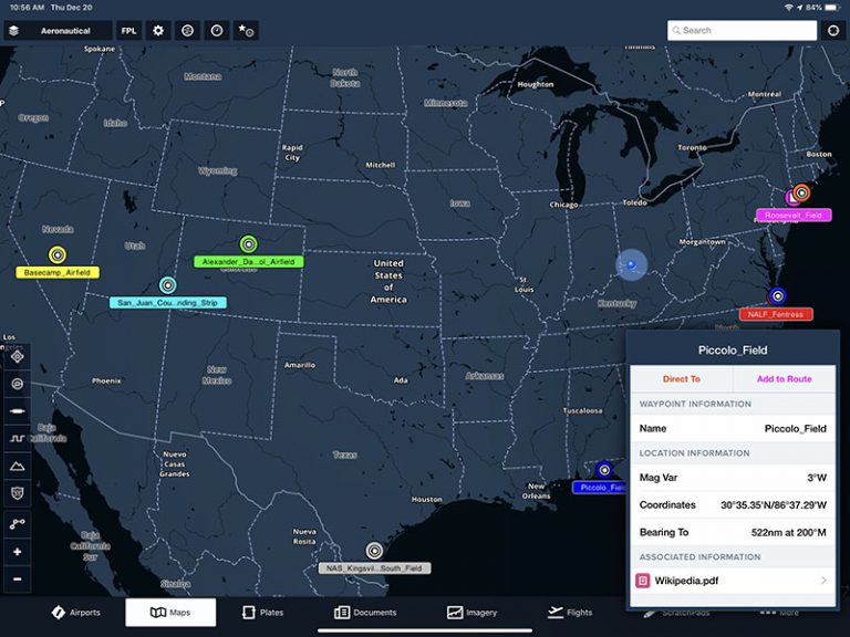
In the example below, you can see abandoned airfields displayed on the Maps tab. Like any airport, you can tap on the airfield for more information.

Tapping on the Associated Information button will bring up a page in the Documents tab. This could be a photo, text or any other PDF with information about the location.

If you tap the map layers menu at the top left, you’ll see some of the custom map layer options displayed at the bottom of the list (see red boxes below).

In addition to data points like the ones above, content packs can include non-aviation charts that are still geo-referenced (so they can be overlaid on the base map). For example, the below screenshot shows a boating map overlaid on the aeronautical map layer.

The possibilities are almost endless with Content Packs. You can learn more in the video below:
The post Trying out ForeFlight’s new content packs feature appeared first on iPad Pilot News.
Source: Ipad appsTrying out ForeFlight’s new content packs feature