Seattle Avionics released a major update to their FlyQ EFB app earlier in the week, which adds new flight recording and augmented reality (AR) functionality. Here’s a quick look at these new features and how to use them.
Flight recorder
The new flight recorder tracks your flight using GPS, allowing you to review the map and details when back on the ground. To access the recording controls, tap the status indicators at the top right corner of the screen, and select the Flight Recorder option from the bottom of the menu. The app features an auto-start recording mode, or you can start it manually with the Start button at the top of the display.

After a flight is recorded, you can email the log, post it on Facebook, Instagram or print it. You can also export the GPX file to view it in CloudAhoy or Google Earth. Or for a quick review in the app, press the blue play button below the title of the flight log name to replay it on the moving map, which includes the option to view it in the synthetic vision view as well.
Flight Tracks
The Flight Track function leaves digital “breadcrumbs” behind your airplane to show your recorded flight path. To display this feature, press the layers button on the left side of the screen, and press the Flight Track button. The flight track begins recording as soon as you start the flight recorder, so you can come back and enable this layer at any time during your flight to see the recorded flight path while still in the air.

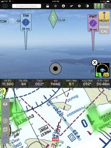
Augmented Reality (AR)
FlyQ EFB 3.0 adds a new nearest airport augmented reality feature, which offers the same functionality as their standalone FlyQ Insight app. To enable this view, tap the 3D cube from the menu on the left side of the maps screen.

After performing a quick calibration out the front window, the app uses your GPS location from either the iPad’s internal GPS if equipped, or a third-party GPS accessory and the accelerometers in your device to keep the airport locations steady in place as you pan around the cockpit. You can then tap on any of the airport markers to get the full details, which would prove useful if you needed to turn towards one for a diversion. You might also find it useful to help locate an airport during hazy days or in an unfamiliar area.
The nice thing about the integration in the FlyQ EFB app is that you can select this view as a split screen option and display it alongside the moving map sectional or airport directory.
What else is new
FlyQ EFB 3.0 now offers full iPhone support, which includes all features included in the iPad version of the app. From a coverage standpoint, you’ll find new helicopter charts and charts for the Gulf of Mexico, along with approach plates and airport diagrams for Mexico and Central America. The update also fixes a previous problem that led to higher CPU utilization in previous versions, which means you should get better battery life after updating.
FlyQ 3.0 is available for download here in the app store
Source: Ipad appsSeattle Avionics FlyQ EFB 3.0 adds flight recording and augmented reality